COXS BAZAR
Cox's Bazar (Bengali: কক্সবাজার Kaksbājār) is a town, a fishing port and district headquarters in Bangladesh.
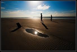
It is known for its wide and long sandy beach which is considered by many as
the world's longest natural sandy sea beach,[2][3][4]
The beach in Cox's Bazar is an unbroken 125 km sandy sea beach with a
gentle slope. It is located 150 km south of the industrial port Chittagong.
Cox’s Bazar is also known by the name Panowa, whose literal translation
means "yellow flower." Its other old name was "Palongkee".
The modern Cox's Bazar derives its
name from Captain Hiram Cox (died 1799), an officer serving in British India.
An officer of the British
East India Company, Captain Cox was appointed
Superintendent of Palongkee outpost after Warren Hastings
became Governor of Bengal. Captain Cox was specially mobilised to deal with a
century-long conflict between Arakan refugees and local Rakhains. He embarked
upon the mammoth task of rehabilitating refugees in the area and made
significant progress. A premature death took Captain Cox in 1799 before he
could finish his work. To commemorate his role in rehabilitation work, a market
was established and named Cox's Bazar ("Cox's Market") after him.
Today, Cox's Bazar is one of the
most-visited tourist destinations in Bangladesh. It has yet to become a major
international tourist destination, and has no international hotel chains, due
to lack of publicity and transportation.

Town
Cox's Bazar (Town), Cox's Bazar
municipality, was constituted in 1869, eventually becoming a B-grade
municipality in 1989. The municipality covers an area of 6.85 km2.[5]
Located along the Bay of Bengal in South Eastern Bangladesh, Cox's Bazar Town
is a large port and health resort. But it is famous mostly for its long natural
sandy beach. The municipality covers an area of 6.85 km² with 27 mahallas and 9
wards and has a population of 51,918.[1]
Cox's Bazar is connected by road and air with Chittagong


History
The greater Chittagong
area, including Cox's Bazar, was under the rule of Arakan kings
from the early 9th century until its conquest by the Mughals in 1666
AD.[7]
When the Mughal Prince Shah Shuja was passing through the hilly terrain of the present-day
Cox’s Bazar on his way to Arakan, he was attracted to its scenic and
captivating beauty. He commanded his forces to camp there. His retinue of one
thousand palanquins stopped there for some time. A place named Dulahazara,
meaning "one thousand palanquins," still exists in the area. After
the Mughals, the place came under the control of the Tipras and the Arakanese,
followed by the Portuguese and then the British.
The name Cox's Bazar/Bazaar
originated from the name of a British
East India Company officer, Captain Hiram Cox, who was
appointed as the Superintendent of Palonki (today's Cox's Bazar) outpost. He
succeeded Warren Hastings, who became the Governor of Bengal following the British
East India Company Act in 1773. Cox was mobilised to
deal with a century-long conflict between Arakan refugees and local Rakhine people
at Palonki. The Captain had rehabilitated many refugees in the area, but had
died (in 1799) before he could finish his work. To commemorate that, a market
was established and named after him, called Cox's Bazar (market of Cox). Cox's
Bazar then was first established in 1854 and became a municipality in 1869.[7]
After the Sepoy Mutiny (Indian
Rebellion of 1857) in 1857, the British
East India Company was highly criticised and
questioned on humanitarian grounds, specially for its opium trade monopoly over the Indian Sub-Continent. However, after its dissolution on 1 January 1874, all of
the company's assets including its Armed Forces were acquired by the British Crown.
After this historic take over, Cox's Bazar was declared a district of the Bengal Province under the British Crown.
Cox's Bazar Map from Series U542,
U.S. Army Map Service, 1955
After the end of British rule in
1947, Cox's Bazar became part of East Pakistan.
Captain
Advocate Fazlul Karim, the first Chairman (after
independence from the British) of Cox's Bazar Municipality, established the Tamarisk Forest
along the beach. He wanted to attract tourists as well as to protect the beach
from tidal waves (tsunami). He donated much of his father-in-law’s and his own lands
as sites for constructing a Public Library and a Town Hall. He was inspired to
build Cox's Bazar as a tourist spot after seeing beaches of Bombay and Karachi,
and was a resort pioneers in developing Cox's Bazar as a destination. He
founded a Maternity Hospital, the Stadium and the drainage system by procuring
grants from the Ford Foundation and Rockefeller Foundation through correspondence. T. H. Matthews, the principal of
the Dacca Engineering College (1949~1954), was a friend who had helped him in
these fundraising efforts. Engineer Chandi Charan Das was the government civil
engineer who had worked on all these projects. In 1959 the municipality was
turned into a town committee.[7]
In 1961 the erstwhile Geological
Survey of Pakistan initiated investigation of radioactive minerals like mo
.0
Cox's Bazar Bus Terminal
In 1971, Cox's Bazar wharf was used as a naval port by the Pakistan Navy's
gunboats. This and
the nearby airstrip of the Pakistan Air Force were the scene of intense shelling by the Indian Navy
during the Bangladesh
Liberation War. During the war, Pakistani soldiers
killed many people in the town, including eminent lawyer Jnanendralal
Chowdhury. The killing of two freedom fighters named Farhad and Subhash at
Badar Mokam area is also recorded in history.[9]
After the independence of
Bangladesh, Cox's Bazar started to get administrative attention. In 1972 the
town committee of Cox's Bazar was turned into a municipality. In 1975, The
Government of Bangladesh established a pilot plant at Kalatali.[8]
Later, in 1984 Cox's Bazar subdivision was promoted to a district, and five years
later (in 1989) the Cox's Bazar municipality was elevated to B-grade.[7]
In 1994 (jobs) the Marine Fisheries and Technology Station (MFTS) was
established at Cox's Bazar. MFTS is a research station of Bangladesh Fisheries
Research Institute (BFRI) headquartered in Mymensingh. The station covers a land area of four hectares and contains
five laboratories.[10]
In April 2007 Bangladesh got connected to the submarine cable network as a
member of the SEA-ME-WE-4 Consortium, as Cox's Bazar was selected as the
landing station of the submarine cable.[11]
In September 2012 the municipality was the site of the Cox's
Bazar and Ramu riots, where local Muslims attacked the
Buddhist community over an alleged Quran desecration
posted to Facebook.[
KUAKATA
Kuakata (Bengali: কুয়াকাটা)
is a panaromic sea beach on the southernmost tip of Bangladesh.[1]
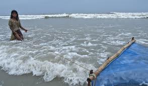
Located in the Patuakhali district, Kuakata has a wide sandy beach from where one can
see both the sunrise and sunset. It is about 320 Kilometres south of Dhaka, the capital, and about 70 Kilometres from the district
headquarters. The Kuakata beach is 30 km long and 6 km wide. On 13
September 2007 government had announced a red alert in Kuakata as caution for a
possible Tsunami.[2]
The name Kuakata originated
from the word 'Kua'-the Bengali word for “Well” which was dug on the sea shore
by the early Rakhine settlers in quest of collecting drinking water, who landed
on Kuakata coast in the eighteenth century after being expelled from Arakan
(Myanmar) by the Mughals.[3]
Afterwards, it has become a tradition of digging Well in the neighborhoods of
Rakhaine tribes for water.
Kuakata offers a full view of the
sunrise and sunset from the same white sandy beach in the water of the Bay of
Bengal.
Locally known as Shagor Kannya
(Daughter of the Sea), the long strip of dark, marbled sand stretches for about
30 km. The long and wide beach at Kuakata has a typical natural setting.
This sandy beach has gentle slopes into the Bay of Bengal. Kuakata is also a
sanctuary for migratory winter birds.
On the eastern end of the beach is
Gongamati Reserved Forest, an evergreen mangrove forest and snippet of the
original Kuakata. When the Rakhines settled in the area in 1784, Kuakata was
part of the larger Sundarbans forest. However, the Sundarbans is now at a distance of
one-hour by speed boat. As a mangrove forest, Gongamati, like the Sundarbans,
offers some protection against tidal surges, however it too is being threatened
by logging and deforestation. The best way to reach the forest is by foot or
bike along the beach, where a flock of flag flying fishing boats can be seen
trawling the coast. Choosing to visit Gangamati in the late afternoon is a
perfect time to watch the sun caste shadows on the abstract exposed mangrove
roots.
Kuakata is the place of pilgrimage
for both Hindu and Buddhist communities. Innumerable devotees arrive here at
the festival of 'Rush Purnima' and 'Maghi Purnima'. On these two occasions the
pilgrims take holy bath at the bay and participate in the traditional fairs.[4]
One may also visit the 100 years old Buddhist Temple where the statue of
Goutama Buddha and two wells of 200 years old are located.
Fisherman village is another place
where you can visit and watch the lifestyle of the fisherman. If you are
adventurous you may also go for fishing on the fishing boat if you can manage
the local fishermen. That will give you pleasure and experience, which you
won’t be able to gather from anywhere else. In the fishermen village you will
find the fishermen coming back from the sea and you can purchase some fresh
hilsha fish from them, and by the side of village there are some local
restaurants where you can get the Hilshas cooked and ready for eating.
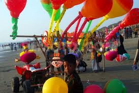
The government and local business
owners have made significant developments over the years to attract tourist to
its shores. Nowadays, local people are more supportive to the tourists and
communications have improved significantly. A new Police station was built in
2007. Accordingly, the law and order situation in the open beach, even at
night, has improved significantly.


PATENGA
Patenga is a popular tourist spot. The beach is very close to the Bangladesh
Naval Academy of the Bangladesh Navy and Shah Amanat International Airport.
Its width is narrow and swimming in the seas is not recommended. Part of the
seashore is built-up with concrete walls, and large blocks of stones have been
laid to prevent erosion. During the 1990s, a host of restaurants and kiosks
sprouted out around the beach area. Lighting of the area has enhanced the
security aspect of visiting at night.Nowadays, alcohol peddling is very common at the beach. Vendors from the city sell their ice creams, cold drinks and food to the hundreds of tourists who come to Patenga Beach. According to the local people, Patenga is the best place for delicious, mouth-watering street food at very low costs. One of the popular dishes of the food stands is the fried, spicy mud crab served with a small plate full of falafel, garnished with cucumber and onion. The beach has a wonderful cool atmosphere even at the evening, and people come to enjoy the soothing breeze. The beach is lined with massive shady palm trees and fishing boats. It also has an array of speed boats for visitors. The beach, however, is quite sandy, with a few rocky patches.
Most visitors come to Patenga Beach as it is known for having some of the most stunning sunsets and sunrises in Bangladesh.


